
.svg)
Capo Mele and Capo Santa Croce: Hiking and Scenic Views in Laigueglia
Capo Mele and Capo Santa Croce: Hiking and Scenic Views in Laigueglia
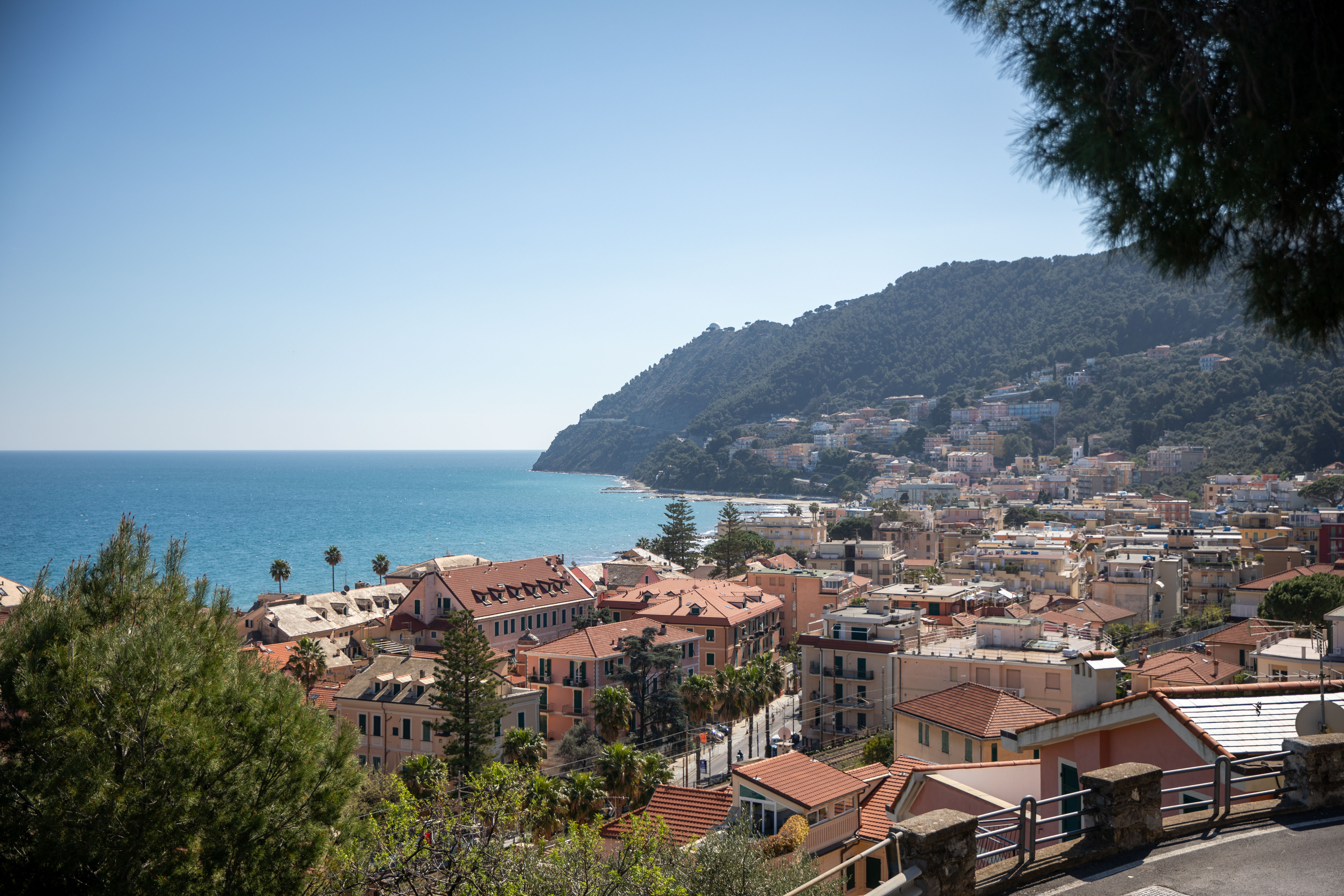
Laigueglia's Baia del Sole is flanked by two promontories that frame the bay from opposite ends: Capo Mele toward Andora, and Capo Santa Croce toward Alassio.
These are more than just scenic view points: they tell fifteen centuries of history, from Benedictine monks and praying sailors to anti-pirate watch towers and sperm whales occasionally spotted offshore.
If you have already explored Laigueglia's walking trails, these two headlands deserve a dedicated visit: not as intense multi-mile hikes,but as relaxing destinations to discover historic lighthouses, coastal chapels,and panoramic views that change throughout the day.
Between Two Headlands: The Geography of the Baia del Sole
Looking out over the coast from Laigueglia, the gulf is effectively enclosed between these two headlands.
Capo Mele is regarded by geographers as the western boundary of the Gulf of Genoa; Capo Santa Croce, just beyond the port of Alassio, closes off the bay on the opposite side. In between lies the Baia del Sole, with its beaches and the historic centre of Laigueglia.
These two headlands do not compete with the routes already described in our guide to outdoor experiences and activities: here, the aim is different – to take your time getting there to enjoy the view, rather than hiking for kilometres along the ridge.
Capo Mele: The Lighthouse, Coastal Winds, and Mediterranean Whales
At Capo Mele, in addition to the military post situated on the highest ridge, stands the Capo Mele Lighthouse, built in 1856 and 25 metres high: one of only three lighthouses in Liguria that are still manned, alongside the Lanterna in Genoa and the Punta Verde lighthouse at Arma di Taggia, which is operated by the Italian Navy. Unfortunately, the lighthouse is not accessible: it is situated within a military zone, as is the higher-altitude signal station, which is reserved for the Italian Air Force’s 115th Remote Radar Squadron and closed to the public.
The best way to explore the area is still on foot, along the path leading from Colla Micheri to Pinamare, in the municipality of Andora: a route through the woods, offering alternating views of the sea and, towards the hinterland, the hills of Stellanello and Testico. You cannot see the lighthouse up close, but it offers an authentic immersion in the Mediterranean scrub of the headland.
The headland also marks the western boundary of the Pelagos Sanctuary, the marine protected area spanning Italy, France and the Principality of Monaco dedicated to cetaceans. It is not uncommon for whale-watching boats to spot sperm whales and pilot whales just off Capo Mele: in 2021, the sighting of a rare white sperm whale, photographed off the coast of Savona, caused quite a stir.
Capo Santa Croce: The Coastal Point Facing Alassio
On the opposite side of the bay, Capo Santa Croce harbours a more intimate history. On the rocky headland stands the Stella Maris Chapel, which the fishermen of Alassio still call ‘la Madonnetta’: built in 1929 in memory of those lost at sea, it stands where an ancient watchtower once stood to ward off Saracen raids, traces of which can still be seen in the foundations. Legend has it that the “Scoglio delle Vedove” (Rock of the Widows) was situated precisely between Capo Santa Croce and Gallinara Island, feared by sailors for the shipwrecks it caused.
A little further up, along the ancient Via Iulia Augusta, you’ll also come across the little church of Santa Croce: according to local tradition, it was built in the 11th century by Benedictine monks who had come from Gallinara Island itself – a link that still connects the two headlands and the offshore island today. Next to it is a small panoramic square that more than makes up for the climb: one of the most evocative views along the entire route, best visited in spring or summer, during the cooler hours of the day.
A short scenic trail also starts from here, ideal for an hour’s walk through the Mediterranean scrub and for birdwatching, before rejoining the ridges of the Alta Via Baia del Sole.
Two Sentinel Headlands: From Roman Times to World War II
Capo Mele and Capo Santa Croce have served as strategic lookouts for millennia. Romans paved the Via Iulia Augusta across these headlands to connect Rome with Gaul; 16th-century towers guarded against pirateraids; and during World War II, military observation posts were established near Mount Bignone, where stone ruins still remain today.
Must-See Viewpoints
- Capo Mele Lighthouse View: Open views across the Gulf of Genoa, spectacular at sunset.
- Stella Maris Chapel at Capo Santa Croce: Picturesque views over Alassio harbor and Gallinara Island.
- Passeggiata Cadorna & Saracen Tower: The most scenic coastal walkway approaching Capo Santa Croce.
- Mount Bignone Ridge Trail: A 360-degree panoramic vantage point overlooking both promontories.
Practical Tips for Visitors
- Best time to visit: spring and autumn, for soft light and mild weather.
- Comfortable footwear: the dirt tracks leading to the lighthouse and the chapel are not particularly challenging, but the ground is uneven.
- Photography: the best light is at dawn towards Capo Santa Croce and at sunset towards Capo Mele.
- Binoculars: useful for trying to spot cetaceans off the coast of Capo Mele during the summer months.
For more details on maps and GPS tracks for the whole area, see the dedicated section on the local network ‘Qui Laigueglia’, or find out how to organise your stay before you set off.
Capo Mele and Capo Santa Croce are the two natural backdrops to the Baia del Sole: all it takes is a stroll and a bit of curiosity to discover a historic lighthouse, a chapel by the sea and centuries of history condensed into these two headlands. Once you’ve explored them, head back to Laigueglia and book your stay with a view of both headlands.
FAQ
Where are Capo Mele and Capo Santa Croce located near Laigueglia? Capo Mele lies to the west toward Andora (marking the western boundary of the Gulf of Genoa), while Capo Santa Croce lies to the east beyond Alassio harbor. Together, they enclose Laigueglia's Baia del Sole.
Can you visit the Capo Mele Lighthouse? The 25-meterlighthouse built in 1856 is located on active military ground managed by the Italian Navy, so the interior is closed to the public; however, the surrounding coastal trails offer great exterior panoramic views.
What is the Stella Maris Chapel at Capo Santa Croce? The Stella Maris Chapel ("La Madonnetta") is a small coastal votive chapel built in 1929 to honor sailors lost at sea, constructed over the ruins of an ancient 16th-century coastal watchtower.
When is the best time to visit Capo Mele and Capo Santa Croce? Spring and early autumn offer mild temperatures and ideal lighting for photography: sunrise is best at Capo Santa Croce, while sunset shines brightest at Capo Mele.